The Spatial Match tool establishes the
spatial relationship (contains, intersects, touches, etc) between two
sets of spatial objects. The tool accepts a set of spatial objects from
the Target Input and a set of spatial objects from the Universe Input.
At least one input stream should contain Polygon type spatial objects.
A Universe input connection into this tool is optional (this file can
be specified via an input path ), as indicated by the white input connection
arrow .
For each record from the Targetâs data
stream, the Spatial Match tool analyzes the spatial objectâs extents and
attempts to find a record in the Universeâs data stream whose spatial
objectâs extents intersect with that of the Target's. If a matching record
is found in the Universe Input, it is sent through the Matched output,
and joined to the Target record. If no matching Universe Input record
is found, the Target record is sent through the Unmatched output.
The Spatial Match tool produces a single or double data stream with one
record for each instance of a Target Input record matching a Universe
Input record. The schema of the output table is formed by appending the
fields from both records into one wide record.
While using spatial tools, you may have more than one spatial object field
in the data stream. When you are configuring the final output tool, you
must remember that output to files such as.dbf,.xls or.csv will not accept
the spatial object fields, and that spatial files will accept only one
spatial object field.
Configure the tool
The Spatial Match
tool accepts two spatial inputs.
Select
the Target Spatial object
from the drop down list
When working with polygons on both sides, the
physically larger polygons should be on the Targets side. When working with polygons
and points, the polygon should be on the Targets side.
Specify
the Universe object:
Use Records from U Input: Select
the Spatial Object field from the data going into the
tool.
Use Records from File or Database:
When reading in spatial objects from a data source, make sure
the data source that is being brought in has already been
sorted on the spatial object. Ensure no connection is going
into the U input.
To
specify the input data source, either type in the file
path location of the input or click Browse to navigate
to the data source's location.
Select
the Spatial Object field from the input data source to
match against. The physically smaller
objects should be on the Universe side.
Specifying
a *.yxdb file for direct import is a more efficient vehicle
for running a Spatial Match. In fact, it is good practice
to convert any static polygon file (such as basic geographies:
States, Counties, etc.) to a pre-sorted *.yxdb file. See the
FAQ for more information.
If specifying a Calgary (cydb) file,
be aware that the Calgary spatial index uses 5 decimal places
of accuracy for compression and speed. The YXDB spatial
index uses 6 decimal places. This adds an addition round
off error of up to a maximum of 1.8 feet to Calgary indexes.
In other words, it is possible that a point can be 1.8
feet inside of a polygon and be found as outside in Calgary.
Specify
the type of Spatial Match to calculate:
Where
Target Intersects Universe: Matches records where both
sets of objects have any area in common.
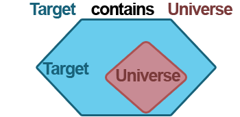
Where
Target Contains Universe:
Matches records where Target objects contain Universe objects
in their entirety.
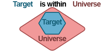
Where
Target Is Within Universe:
Matches records where Target objects are entirely within Universe
objects.
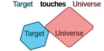
Where
Target Touches Universe: Matches records
where Target objects touches the outside boundary of Universe
objects. To qualify as touching, neither object can occupy any
of the same interior space.
Where
Target Touches
or Intersects Universe:
Matches records where Target objects either share interior space
with Universe objects, or touch the boundary of Universe objects.
or
Bounding
Rectangle Overlaps: Matches records where the bounding
rectangles of Target objects and Universe objects share interior
space.
Custom
DE91M Relation: User
must be familiar with DE-91M relations to enter the custom value.
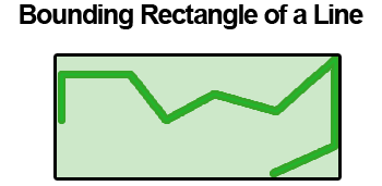
When bringing
Line type objects into the Spatial Match, matching is based on
the bounding rectangle only.
Notice
the check box to output the intersection polygon, when checked
the intersection polygon will be included in downstream tools.
This
option is only available when Intersects is selected,
and is only relevant when matching polygon to polygon.
The
intersection polygon refers ONLY to the area occupied by BOTH
polygon Objects.
Use the table to modify the incoming data stream. Each row in the table represents a column in the data.
To change the supported length (characters for string and numeric fixed decimal types) or measurement (bytes for other numeric types) of data in a column, click Size and type a number. Size varies by data type and can be edited for fixed decimal numeric types and all string types. See Data Types.
Use the [data type]: Forced option to ensure a column always contains the expected data type; this is helpful when creating macros. See Macros.
After selecting or highlighting rows (columns of data) in the table, click Options to view more configuration options:
Save/Load: Save the column configuration as a .yxft file. The Alteryx Field Type File is a text file can be used in other workflows using the Load Field Names or Load File Names and Types options.
Select: Select or deselect all or highlight columns. Options include Select All and Deselect All.
Change Field Type of Highlighted Fields: Change the data type of all highlighted columns at once.
Sort: Sort the column order in ascending or descending order. Options include Sort on Original Field Name, Sort on New Field Name, and Sort on Field Type, or Revert to Incoming Field Order.
Move: Move highlighted columns to the top or bottom of the list.
Add Prefix to Field Names: Add a prefix to the selected or highlighted column name.
Add Suffix to Field Names: Add a suffix to the selected or highlighted column name.
Remove Prefix or Suffix: Remove the prefix or suffix from the selected or highlighted column name.
Clear All Renames: Remove the new name for all column.
Clear Highlighted Renames: Remove the new name for all highlighted columns.
Revert All to Original Type and Size: Undo all changes to type and size in all columns and use the original values.
Revert Highlighted to Original Type and Size: Undo changes to type and size in the selected or highlighted columns and use the original values.
Forget All Missing Fields: Remove all columns that are no longer included in the data.
Forget Highlighted Missing Fields: Remove all highlighted columns that are no longer included in the data.
Deselect Duplicate Fields: Deselect the second column when duplicate column names exist; this optional is only available with multiple inputs.
Output Streams of the Spatial Match Tool
There are two Output Streams on the Spatial Match tool:
M indicates
Matched records:
The records that come from out
of this stream will beTargetrecords whose object that had a
match from theUniversestream. The Universe object and
selected fields are joined to the Target Record.
A
Target record may come out of the matched side any number of times,
depending on how many Universe objects are matched.
U indicates
Unmatched records:
The records that come from out
of this stream will beTargetrecords whose object that had no
match from theUniversestream.
 Spatial Match Tool
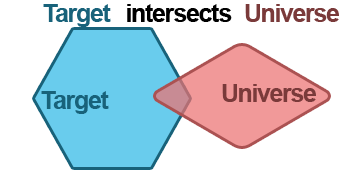

 or
or  arrows, or right-click and drag, to move the rows to a new location.